1933 - Regular air Services
to the Isle of Man
In March 1933 Blackpool
and West Coast Air services was established with a main base at Blackpool
Aerodrome and operated charter services to Ronaldsway using a DH83 Fox
Moth. By August they were operating scheduled services with one daily flight
from Liverpool and two from Blackpool using a twin engine de-Havilland
DH84 Dragon G-ACGU. These services stopped for the winter in September
but in 1934 four other companies were operating to Ronaldsway, Midland
& Scottish Air Ferries, Hillman Airways, Northern Airways and Railway
Air Services. Towards the end of 1934 Captain Olley of Olley Air Services
acquired Blackpool & West Coast with Captain Higgins as chief pilot
and secured the landing rights at Ronaldsway, a temporary aerodrome license
was issued to Ronaldsway at the start of 1934 pending improvements to the
airfield and facilities.
A hanger capable of
housing a DH Dragon was erected together with a wooden traffic office,
the hanger not lasting long, being blown down in February and subsequently
replaced by a larger structure in March. A holding company, Isle of Man
Air Services was created to run the aerodrome and other airlines had to
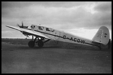
pay to use the facilities. Blackpool & West Coast now had four Dragons
in service: G-ACGU, G-ACNA, G-ACPY and G-ADCR. In 1936 the airline introduce
four engined de-Havilland DH86 'Express' airliners and with the Irish Airline,
Aer Lingus Teoranta starting services from Dublin, Ronaldsway was becoming
a hub for routes across the Irish Sea.
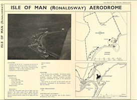 Isle of Man (Ronaldsway)
Airport
From 1938 Newnes
Aeronautics Guide
Isle of Man (Ronaldsway)
Airport
From 1938 Newnes
Aeronautics Guide
|
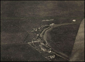 Enlargement of the
aerial photo of Ronaldsway
from Newnes 1938
guide
Enlargement of the
aerial photo of Ronaldsway
from Newnes 1938
guide
|
Ronaldsway in the
1930s courtesy of the Terry Farragher Collection
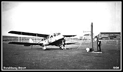 Blackpool & West
Coast DH84 Dragon G-ACPY
refuelled by Shell
- 1934
Blackpool & West
Coast DH84 Dragon G-ACPY
refuelled by Shell
- 1934
|
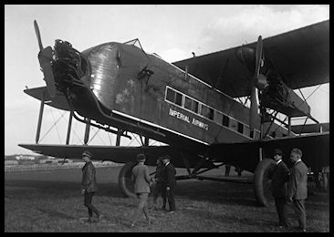
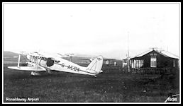 Railway Air Services
DH89 Dragon Rapide
G-AEBX 'Star of Scotia'
- 1936
Railway Air Services
DH89 Dragon Rapide
G-AEBX 'Star of Scotia'
- 1936
|
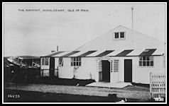 Airport Buildings
- 1936
Airport Buildings
- 1936
|
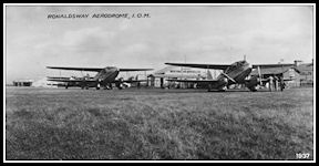 DH86 Express G-ADVJ
with
DH89 Rapide G-AEAK
- 1937
DH86 Express G-ADVJ
with
DH89 Rapide G-AEAK
- 1937
|
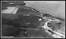 1938 Aerial view
of Ronaldsway
1938 Aerial view
of Ronaldsway
|
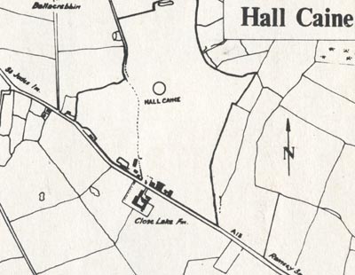
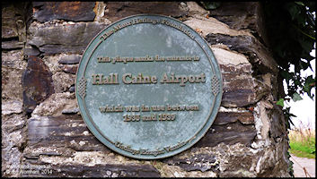
Hall Caine Airport, Ramsey
In 1934 a rival to Ronaldsway
was established at Close Lake, just to the west of Ramsey on the St Jude's
road, named after the famous Manx author Sir Hall Caine. Services commenced
in April 1935 operated by United Airways using three engined Spartan Cruiser
monoplanes. One service per day operated Blackpool - Hall Caine - Carlisle
and return and three others Liverpool - Blackpool - Hall Caine and return.
From May 1935 Northern & Scottish commenced a weekly service from Glasgow
building up rapidly until it became twice daily by July. A series of airline
amalgamations took place by the end of the year resulting in a new company,
British Airways Ltd being formed. In the summer of 1936, Northern &
Scottish (operating on behalf of British Airways) were operating Glasgow
services twice a day, Liverpool and Blackpool twice or three times a day
and once a day to Belfast and Carlisle. Aircraft used were Spartan Cruisers,
Dragons and Dragon Rapides, with occasional visits by an Armstrong Whitworth
Argosy which could carry up to 28 passengers. Both passengers and mail
were handled and there is a mention in 'Manx Aviation in War & Peace'
that on the 12th September 1936, 28 flights were handled, carrying 69 passengers,
612 lb of Mail and 1,375 lb of baggage. Despite such a busy season in 1936,
airline operation had ceased by the following year, the last scheduled
flight leaving on the 2nd August 1937, the aerodrome remaining open for
private flying until the outbreak of war in September 1939. Although M/F
W/T radio was installed at Hall Caine for airline message handling, there
was never any ATC service offered.
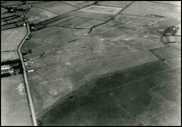 Aerial view of Hall
Caine Airport in the 1930s
Aerial view of Hall
Caine Airport in the 1930s
|
 Hall Caine Aerodrome
Diagram
Hall Caine Aerodrome
Diagram
|
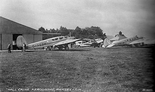 Hall Caine Airport
with Spartan Cruisers and a DH Dragon
Hall Caine Airport
with Spartan Cruisers and a DH Dragon
|
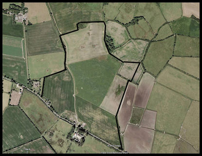 Google Earth image
of the area occupied
by Hall Caine Airport
Google Earth image
of the area occupied
by Hall Caine Airport
|
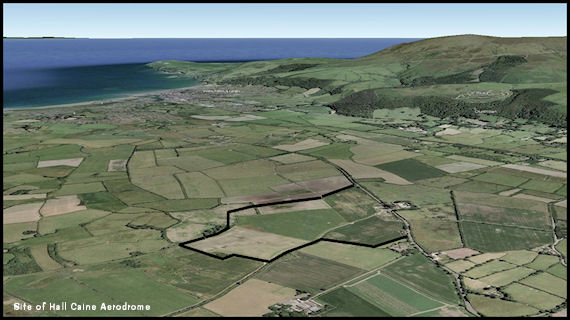 Oblique Google Earth
view of the site occupied by Hall Caine
Airport, with Ramsey
behind
Oblique Google Earth
view of the site occupied by Hall Caine
Airport, with Ramsey
behind
|
 Spartan Cruiser
|
 Armstrong Whitworth
Argosy
Armstrong Whitworth
Argosy
|
 Hall Cain Airfield
diagram from the 1939 Air Pilot
Hall Cain Airfield
diagram from the 1939 Air Pilot
|
 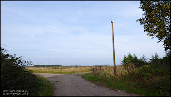 Hall Caine in 2014
|
Some other airfields
with services to the Isle of Man
Diagrams from the 1938
Newnes Aeronautics Guide. Click for larger and use your browser 'Back'
button to return here.
 Liverpool (Speke)
|
 Manchester (Barton)
|
 Blackpool (Stanley
Park)
Blackpool (Stanley
Park)
|
 London (Croydon)
|
 Glasgow (Renfrew)
|
 Leeds/Bradford (Yeadon)
|
Air Traffic Control in the UK
The first Air Traffic
Controller's licence had been issued to G.J.H. 'Jimmy' Jeffs on the 22nd
February 1922, although it would appear that his initial task was to actually
decide how aircraft could be controlled from the ground in the first place!
Initially control was just over aircraft landing and taking of from the
grass aerodrome at Croydon by flag and light signals, no control was provided
to aircraft once they had left the immediate vicinity of the airport, although
radio and radio direction finding sytems were established to assist pilots
with navigation. Away from the aerodrome it was entirely up to individual
pilots as to what routes to fly and whether or not to communicate with
the ground stations by radio. Many aircraft didn't even carry radio.
However, by the early
1930s in the London area, commercial air traffic was becoming much busier
with aircraft capable of flying in cloud 'on instruments' and it was decided
by the UK Government that something had to be done to improve safety when
aircraft were operating in conditions of poor visibility - mandatory Air
Traffic Control over a wider area was about to start in Great Britain.
November 19th 1933
- First UK mandatory Air Traffic Control Service established at London
Croydon
Due to the ever increasing
danger of aerial collisions in bad weather, the first UK Air Traffic Control
service was introduced at Croydon Airport, London. An irregularly shaped
'Controlled Zone' based on geographical features came into operation when
visibility dropped to below 1000 yards or cloud was below 1000 ft - in
the 'Q' code used for the W/T (morse) communications of the day this was
'QBI'.
Standard routes were
also defined over south east England, mainly following railway lines and
using the 'right hand traffic' rules , i.e. every aircraft flew to the
right hand side of a line feature which would hopefully allow opposite
direction aircraft to pass well clear.
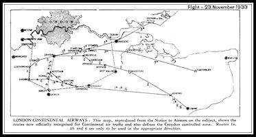 Click for map of
Croydon Controlled Zone and air routes
If 'QBI' was in force,
pilots had to obtain permission by wireless before entering the zone or
land clear at another airfield and wait for the weather to improve. Departing
aircraft captains would report in person to control for any departure restrictions
before taxiing to the departure point on the airfield and awaiting a light
signal from the 'lookout man' when cleared for take off by the controller.
Click for map of
Croydon Controlled Zone and air routes
If 'QBI' was in force,
pilots had to obtain permission by wireless before entering the zone or
land clear at another airfield and wait for the weather to improve. Departing
aircraft captains would report in person to control for any departure restrictions
before taxiing to the departure point on the airfield and awaiting a light
signal from the 'lookout man' when cleared for take off by the controller.
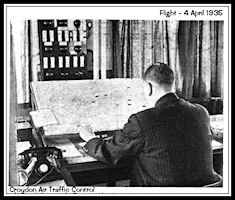 Croydon ATC 1935
|
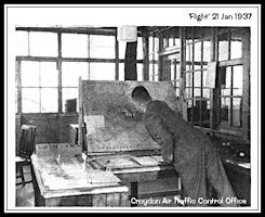 Croydon ATC 1937
|
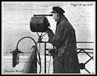 'Lookout Man' Croydon
Airport 1937
'Lookout Man' Croydon
Airport 1937
|
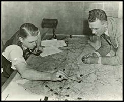
After becoming airborne
the pilot or wireless operator would pay out the long trailing aerial required
for the Medium Frequency radios used and make contact with control, reporting
when level at his assigned altitude and when he estimated clear of the
controlled zone. Direction finding (D/F) bearings would be available to
assist navigation of both inbound and departing aircraft and control would
plot positions of aircraft based on D/F bearings from Croydon, Lympne and
Pulham. Each station would report a 'bearing line' on a transmission and
by plotting these on a map a position could be obtained for the aircraft.
The controller would mark aircraft positions on his map using coloured
flags and information on conflicting flights together with suggestions
on altitudes or routes to be flown would be transmitted to pilots.
'Communications Areas' were established over southern England within which
pilots could contact a control agency by radio and obtain information on
other aircraft together with advice on avoiding aerial collisions, e.g.
a change in altitude.
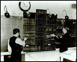
 Plotting D/F Bearings
- Croydon 1937
Plotting D/F Bearings
- Croydon 1937
|
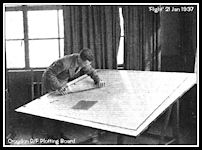
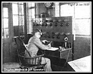 Radio Operator -
Croydon 1937
Radio Operator -
Croydon 1937
|
Air Traffic Control in the USA
Across the Atlantic
it was also realised that some sort of control was needed to prevent collisions
between aircraft at airfields, so in the late 1920s a system of 'Flag men'
was established at a few airports, the first being at St Louis, Missouri
in 1929. By the early 1930s, airports were starting to be provided
with control towers equipped with radio, these early ATC units were operated
by the airlines and only controlled traffic within visual range of the
controller. Routes between cities, later know as 'Airways' were defined
by light beacons at night, but in the early 1930s 'Radio Range' stations
became established enabling pilots to safely navigate along the route in
cloud, creating the possibility of mid air collisions between aircraft
'following the beam'. In 1935 the US Government published a set of
rules governing flights using instruments along the airways and by the
end of the year the first 'Airway Traffic Control Station' was established
at Newark, New Jersey, with further stations opening in 1936 at Chicago
and Cleveland. Initially operated by the airlines, the US Government
took over operations in July 1936 and hired 15 'Airways Controllers', mainly
the airline staff who had been doing the job already. Control of
traffic was based on Flight Plans received from the airlines and radio
reports filed to airline dispatchers which were then telephoned to the
controllers. These messages were recorded onto a blackboard and then used
to plot aircraft positions on a chart using 'Shrimp Boats' - small wooden
markers holding a piece of paper with the aircraft details. Positions
were updated every fifteen minutes and control instructions relayed to
the aircraft via the airline dispatch offices. Control only applied
to aircraft flying under the 'Instrument Flight Rules', aircraft flying
visually could proceed as they wished although airliners were encouraged
to report their positions to control.
 Newark Airway Traffic
Control Station, 1930s
Newark Airway Traffic
Control Station, 1930s
|
 Plotting Aircraft
Positions
Plotting Aircraft
Positions
|
The number of Airway
Traffic Control Stations was rapidly expanded once under government control
and by the end of 1939 there were twelve in operation. Also established
during the 1930s and 1940s were 'Approach Control' units at airports, controlling
aircraft beyond the visual range of the tower controllers. In this
regard the USA seemed to lag behind the UK, as Croydon Airport was effectively
operating Approach Control from 1933.
 Washington Centre
1943
Washington Centre
1943
|
 Chicago Tower, 1943.
Note use of Flight Progress Strips
Chicago Tower, 1943.
Note use of Flight Progress Strips
|
Whilst in Europe the
outbreak of World War Two halted the expansion of civil aviation, it continued
apace in the USA and by the end of the war there were twenty eight centres,
serving air routes defined by the medium frequency Radio Ranges and Non
Directional Beacons (NDBs). The developments in the USA were to have
a profound influence on development of ATC procedures in the UK and Europe
in the 1950s, with Radio Ranges being established to define new airways
and Air Traffic Control Centres set up to control aircraft. This
is covered in more detail in the 1950s
section.
8th July 1937,
Air Traffic Control Service Established at Ronaldsway - 'GJE' on 363Khz
Only three and a half
years after ATC started at Croydon Airport, Air Traffic Control was established
at Ronaldsway Airport. This was due to the large number of commercial flights
operating acros the northern Irish Sea, many of them stopping at the Isle
of Man. Whereas in the UK, the preferred mode of long distance travel for
most was by the extensive railway network, travel to the island involved
a lengthy and often rough boat journey across the Irish Sea. Air travel
for those who could afford it was much faster and more comfortable.
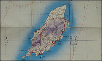
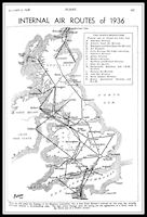 Map of Internal Air
Routes 1936
Map of Internal Air
Routes 1936
|
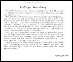 'Flight' article
- 'Radio for Ronaldsway' 1937
'Flight' article
- 'Radio for Ronaldsway' 1937
|
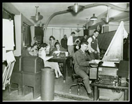
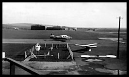
Ronaldsway first
'Control Tower'
The first ATC Watch
Office at Ronaldsway. Located next to the airport terminal at Derbyhaven
with the direction finding station close by. The radio receiving aerials
were adjacent, but the 70' high transmitter aerials were further to the
west. Signals to aircraft and other ground stations would be passed on
colour coded message slips to the W/T operators in the room behind the
control office for transmitting by Morse Code. Replies would be similarly
passed on message slips.
 The 1937 Ronaldsway
Watch Office
The 1937 Ronaldsway
Watch Office
|
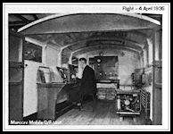 Mobile Marconi D/F
Station
Mobile Marconi D/F
Station
|
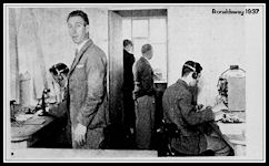 Ronaldsway Radio
Room 1937
Ronaldsway Radio
Room 1937
|
From the Newnes 1938
Ronaldsway page and the 1939 Air Pilot, it would appear that signals giving
permission to land and take off were probably not used at Ronaldsway.
In accordance with the Air Navigation Order, it was up to pilots to ensure
that they formed a proper traffic circuit and landed or departed in turn,
making a left turn after landing as subsequent aircraft might be landing
to their right. If required, supplementary instructions could be
given from the ground by Aldis signalling lamp or a coloured very pistol
signal. Initially the colours used varied from location to location, but
a standard set of signals was agreed and can still be used today, although
from personal experience very few pilots seem to look at the tower for
such signals even if they have a known radio failure!
Aldis Signalling
Lamp - 2012
 Demonstrating that some
things never change in ATC!
Demonstrating that some
things never change in ATC!
|
The Controlled Zone
A 'Controlled Zone'
was established on the 8th July 1937 comprising a circle 10 miles around
Ronaldsway to a height of 3000 ft. Control only came into action in 'QBI'
- i.e. poor weather conditions. The principle was one aircraft inside
the zone at a time, arriving and departing aircraft could be assigned levels
to fly and expected times to enter the zone. If QBI was not in force, aircraft
could arrive overhead the airfield to observe the ground signals square,
which would give them the information needed as to landing and circuit
direction. As the airfield was grass, with no delineated runways, the 'Landing
Tee' was pivoted to rotate with the wind and pilots would always land into
wind. In light winds the Tee would be fixed in one direction to avoid confusion
if it drifted around.. Pilots would join the visual circuit keeping a good
lookout for other aircraft and touch down once the landing area was clear
of other aircraft. Unless otherwise instructed all turns were to be made
to the left.
 Signals Square at
Manchester Barton
Signals Square at
Manchester Barton
|
 Signals Square at
Ronaldsway - 1950s
Signals Square at
Ronaldsway - 1950s
|
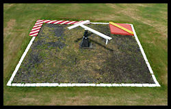
Landing Tee
Although the zone was
'Controlled' in QBI conditions, this really only extended to regulating
aircraft entering and leaving the zone. Once cleared inside, it was up
to the pilot how he conducted his flight. D/F bearings would be passed
as requested and it was up the him to decide what headings to fly and what
was a safe height to descend to. In low cloud at Ronaldsway it would be
likely that a pilot would obtain bearings until he was indicated overhead
the D/F station and then set a course to let down over the sea until he
was visual with the surface, obtaining regular bearings and using time
to estimate his position. The controller or his assistant would stand outside
the watch office and listen for the aircraft engines and a message would
be passed to the pilot, e.g. 'engines east'. Once visual with the surface
further D/F bearings could be passed to 'home' the aircraft back towards
the airfield.
The Isle of Man and Manchester
Communications Area
A new 'Communications
Area' was established over the northern Irish Sea, jointly administered
by Ronaldsway and Manchester Barton. A purpose designed brick control tower
had been built at Barton in 1933 and is still in use today. Positions of
aircraft would be plotted on a map based on position reports and estimates
from the pilots. A frequency of 363 KHz was used (by both Ronaldsway and
Barton), using W/T - wireless telegraphy by means of Morse Code. (Speech
Radio Telephony had been used by aircraft previously, but was largely abandoned
by this time due to congestion on the very limited frequencies available).
Radio equipped passenger aircraft would carry a wireless operator as it
would not have been practical for the pilot to both fly the aeroplane and
operate the radio. Direction finding bearings were available to assist
pilots in navigation, but this would be a time consuming process as bearings
were manually obtained at the ground stations before being re-transmitted
to the aircraft. To keep messages short, the 'Q' code was used, most regular
phrases needed being covered by a three letter code starting with the letter
Q. More information on the 'Q' code below.
 Communications Areas
& Controlled Zones
January 1938
Communications Areas
& Controlled Zones
January 1938
|
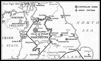 The Isle of Man &
Manchester
Communications Area
1938
The Isle of Man &
Manchester
Communications Area
1938
|
 Manchester Barton
1930s Control Tower in 2013
Manchester Barton
1930s Control Tower in 2013
|
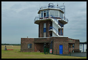
 Liverpool Speke Airport
1930s Control Tower in 2009
Liverpool Speke Airport
1930s Control Tower in 2009
|
As the controllers had
no authority to issue compulsory instructions within the area, information
on conflicting known flights would be passed together with 'suggestions'
as to how the conflict could be resolved. Most pilots, if flying 'blind'
in cloud would have been only too pleased to accept the suggestions!
The controllers didn't
communicate directly with aircraft, messages from pilots were received
by radio operators and transcribed onto paper message slips, colour coded
according to the message type, before being passed to the controller. After
considering his actions, the controller would write his reply onto another
message slip and pass it to the radio operator for transmission to the
aircraft.
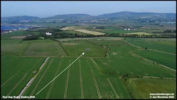
Ballahick and Red Gap Radio Stations
In 1936 two new radio
stations had been constructed to serve Ronaldsway. A transmitting
station at Ballahick, just outside Ballasalla and a recieving and Direction
Finding station at Red Gap, just west of Castletown. The Red Gap
d/f station used the 'Adcock' system which gave more accurate bearings
during the hours of darkness. This needed to be located away from the airfield
due to the four 100 ft high radio masts needed. These were arranged in
a square with a quite large building in the centre, housing the wireless
equipment and plotting table. Both buildings still exist in 2020, Ballahick
has been converted into a private residence and Red Gap is a ruin.
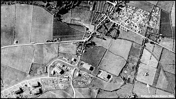 Aerial view of Ballahick
in 1944
Aerial view of Ballahick
in 1944
|
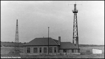 The Ballahick Transmitting
Station in 1958
The Ballahick Transmitting
Station in 1958
|
 Aerial view of the
Red Gap Radio Station site in 2020
Aerial view of the
Red Gap Radio Station site in 2020
|
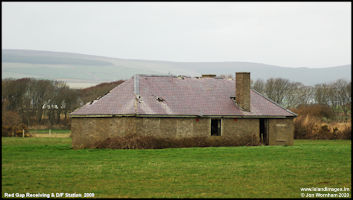 Red Gap Receiving
and Direction Finding Station - 2009
Red Gap Receiving
and Direction Finding Station - 2009
|
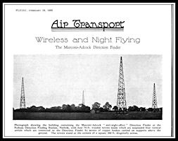 Adcock Direction
Finding station at Pulham
Adcock Direction
Finding station at Pulham
|
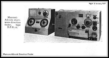 Marconi-Adcock Direction
Finding Receiver
Marconi-Adcock Direction
Finding Receiver
|
'Flight' Diagram of working
a Controlled Zone in QBI
(Click either image
below for full diagram)
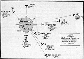 Controlled Zone around
aerodrome 'XEP'
Controlled Zone around
aerodrome 'XEP'
|
 'Q' codes used and instructions
issued
'Q' codes used and instructions
issued
|
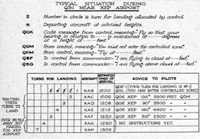
A typical flight to Ronaldsway
in QBI conditions
Some sets of message
slips have survived from the 1930s and we can follow the flight of Dragon
Rapide G-AFFF from
Glasgow Renfrew to Ronaldsway
on the 14th June 1939.
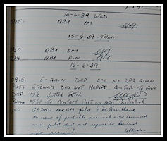 ATC Watch Log
entry for 14 June 1939
showing 'QBI' in
force
The weather was poor
at Ronaldsway so the Controlled Zone was in operation (QBI). Each slip
represents a message sent using Morse Code between the aircraft and a ground
station. Extensive use was made of the 'Q Code' to shorten transmissions.
There were 33 messages in total to get one aircraft into land! The 'ATC
Diary' entry for the day indicates that QBI had been in force from 07:55.
If I've worked this out correctly. pink slips are for arrival and departure
messages, white slips for 'general' messages from and to the W/T station
and green slips are for Air Traffic Control messages.
Follow
the Flight
ATC Watch Log
entry for 14 June 1939
showing 'QBI' in
force
The weather was poor
at Ronaldsway so the Controlled Zone was in operation (QBI). Each slip
represents a message sent using Morse Code between the aircraft and a ground
station. Extensive use was made of the 'Q Code' to shorten transmissions.
There were 33 messages in total to get one aircraft into land! The 'ATC
Diary' entry for the day indicates that QBI had been in force from 07:55.
If I've worked this out correctly. pink slips are for arrival and departure
messages, white slips for 'general' messages from and to the W/T station
and green slips are for Air Traffic Control messages.
Follow
the Flight
              
               ATC & M/F D/F
message slips for just one aircraft to enter the Controlled Zone and be
'homed' into Ronaldsway
ATC & M/F D/F
message slips for just one aircraft to enter the Controlled Zone and be
'homed' into Ronaldsway
|
ATC Developments
Even in
this period ATC was becoming
overloaded with traffic and it was suggested that medium frequency radio
'beacons' were set up to allow suitably equipped aircraft to obtain their
own bearings to stations using on board direction finding equipment. The
equipment was bulky which meant that it was only really practical in the
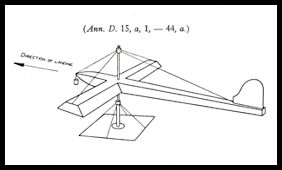
airliners of the day. At Croydon Airport a 'Lorenz' radio beam system was
installed in 1936 to enable aircraft to approach the airport in poor visibility
and descend on a safe path until the airfield appeared ahead (hopefully!)
The 'beam' could be followed either aurally (through the pilots headphones
or by using a special instrument. This was the for-runner of today's Instrument
landing Systems. (ILS)
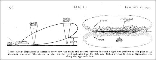 'Flight' diagram
from 1935 showing the principle of the Lorenz system
'Flight' diagram
from 1935 showing the principle of the Lorenz system
|
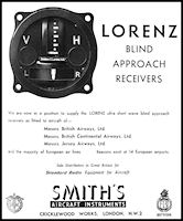 Advert for a Lorenz
receiver and indicator, made by Smith's
Advert for a Lorenz
receiver and indicator, made by Smith's
|
Codes and SIgnals
Before the widespread
introduction of Radio Telephony (R/T) i.e. speech transmissions, which
started for RAF fighter aircraft in the 1940s and only became prevalent
for civil aircraft with the introduction of VHF radios in the 1950s, methods
were devised for signalling between aircraft, ships and ground stations.
Many used ground markings, flags, light and pyrotechnic signals and an
international 'Code of Signals' was devised and published under the Air
Convention of 1919. The book illustrated on the left was issued by
the UK Air Ministry in 1940 and consists of 156 pages illustrating these
various codes and signals. In addition, a system of three letter
codes that could easily be transmitted using Morse Code on Wireless Telegraphy
(W/T) was introduced from 1913 onwards, initially for ships but expanded
for aviation use in the years following WW1 when radio equipment became
more commonly fitted to aircraft. The second volume illustrated is
a much more modern version issued by the International Civil Aviation Organisation
(ICAO), this one being the fourth edition published in 1989.
 Air Ministry 1940
Signal Book
Air Ministry 1940
Signal Book
|
 ICAO Abbreviations
& Codes 1989
ICAO Abbreviations
& Codes 1989
|
Light and Ground
Signals
Some of the light signals
and ground information signals persist in use today, the two illustrations
below from
a 2010 'AFE Flight Guide'
illustrate some of them.
 Light Signals
|
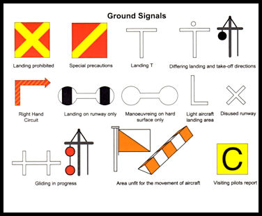 Ground Signals
|
Sample 'Q' Codes
The Same 'Q' Code could
be used as either a question or an answer and a selection of codes are
shown below. I have paraphrased some for the sake of brevity, many
'Q' codes contain multiple options.
|
QAB
|
May I have clearance
for....
|
You are cleared.....
|
|
QAH
|
What is your height
above...
|
I am at altitude...
|
|
QAL
|
Are you going to land
at...
|
I am going to land at...
|
|
QAM
|
What is the latest meteorological
observation for...
|
Meteorological observation
is...
|
|
QBF
|
Are you flying in Cloud?
|
I am flying in cloud
at altitude...
|
|
QBI
|
Is flight under IFR
(Instrument Flight Rules) compulsory?
|
Flight under IFR is
compulsory
|
|
QDM
|
What is the magnetic
heading to steer to you?
|
The magnetic heading
to steer to me is...
|
|
QFE
|
What (pressure) should
I set on my altimeter to read height?
|
Set.... on your altimeter
to read height.
|
|
QFU
|
What is the runway in
use?
|
The runway in use is...
|
|
QNH
|
What should I set on
my altimeter to read altitude?
|
Set.... on your altimeter
to read altitude.
|
|
QRM
|
Are you being interfered
with?
|
I am being interfered
with.
|
|
QRZ
|
Who is calling me?
|
... is calling you.
|
|
QSY
|
Shall I change to another
frequency?
|
Change to another frequency
(can be specified)
|
|
QTH
|
What is your position?
|
My position is...
|
|
QTO
|
Are you airborne?
|
I am airborne.
|
There are a total of
248 'Q' codes in the 1989 publication and any good pilot, radio operator
or Controller would be expected to know all of the relevant ones used in
everyday operations. The message slips shown above show that they
were used on the written messages between controller and radio operator
just as much as actually on the radio. Some of the codes are still
in daily use today as telephony abbreviations, such as QNH, QFE, QDM,
QSY.
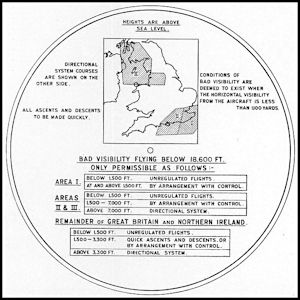
A 1939 ATC System Roundup
By then end of the decade,
the ATC system had expanded to include several 'Controlled Zones' around
busy airports, including Ronaldsway, plus three 'Civil Aviation Areas'
where a control service was provided from the ground to aircraft operating
in 'Cloud or Reduced Visibility' (1939 Air Pilot). This was defined
as when the base of a continuous cloud level was less than 1,000 feet above
sea level, which was known as 'Visibility 3 Minus' from the equivalent
height in metres. In flight it was defined as when horizontal visibility
was less than 1,000 metres.
If flying in clear weather
pilots could choose courses and level as they wished but in what we now
call Instrument Meteorological Conditions a separate set of rules applied.
If flying below 1,500 feet or above 18.600 feet, flights were unrestricted,
but otherwise pilots had to obey certain rules designed to prevent them
coming into close proximity. Within the zones and areas, pilots request
and be allocated altitudes to fly at that would prevent them coming into
conflict with other aircraft, but such controlled areas only covered a
small proportion of UK airspace and so a system know as the 'Directional
System' was mandated. The diagram below illustrates how it applied
do different areas and levels.
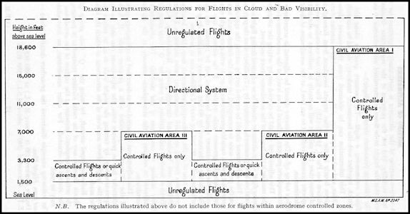 1939 Airspace Regulations
Diagram (from 1939 'Air Pilot')
1939 Airspace Regulations
Diagram (from 1939 'Air Pilot')
|
Civil Aviation Area
III, which covered the Manchester and Liverpool areas, north over Cumbria
and up to just north of Glasgow, then west to include Belfast and south
to the North Wales coast was controlled from Manchester Barton. There
were separate W/T radio frequencies for the Main Area and West Areas.
For the West Area, Ronaldsway was listed as a 'collaborating station',
but there seems to have been no third direction finding station available
to enable the exact position of an aircraft to be fixed by wireless.
Other aeronautical wireless stations around the north west area were located
at Manchester Ringway, Glasgow Renfrew and Newtownards in Northern Ireland.
There is an entry in a Ronaldway log book about them 'taking over' from
Manchester when the latter were having radio problems.
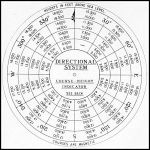
The Directional
System
If pilots were flying
in Reduced Visibility Conditions (including in cloud) outside the zones
and areas, they had two options available to them, either fly below 1,500
feet or in compliance with Directional System. If the latter they
were required by regulations to carry a 'Course Height Indicator' to calculate
the appropriate altitude to fly at. Flight between 1,500 feet and 3,300
feet was discouraged unless under ATC Control or for climbing and descending
as quickly as possible.
Further south, in Civil
Aviation Area I, a much more comprehensive control system was operating,
although still only in conditions of reduced visibility. In addition
to the air traffic control services offered, two 'Air Routes' were defined
for traffic operating from the coast of SE England routing towards the
airports in the London Area. Controlled from Croydon, aircraft postiions
could be determined by wireless direction finding using the stations at
Croydon, Lympne and Pulham. At night the routes were defined by light
beacons where required, the forerunner of later airways defined by radio
beacons.
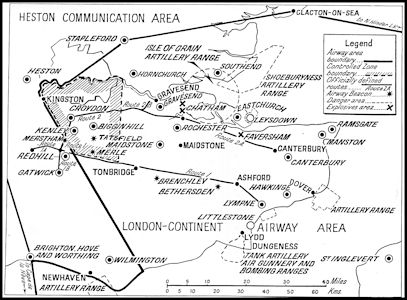 The London - Continent
Airway Area in 1939
The London - Continent
Airway Area in 1939
|
All of these civil air
traffic control developments were to be suspended later on in the year
after the momentous events of September that year with the outbreak of
war and it was not until the late 1940s that most would be re-introduced,
although a service was provided from Ronaldsway and Liverpool throughout
the wartime years.
Wartime
On the 1st September
1939 as Nazi Germany invaded Poland, an Air Ministry air traffic controller
arrived at Ronaldsway to assist in training the local staff in requirements
for wartime operation. Signals now needed to be encoded before sending
via radio and pilots needed to be issued with the 'colours of the day',
recognition Very lights to be fired if challenged by a fighter aircraft
or a ship. With war declared on 3rd September, civil air services were
cancelled and all aircraft ordered to the UK for possible impressment into
military service. However, the importance of the Isle of Man air route
was recognized and a limited service was re-instated from November 1939,
using Dragon Rapides. All flights had to be authorized in advance, but
there were often occasions when they were challenged by ships. Special
routes had to be followed into the Liverpool area to avoid the protecting
barrage balloons and anti-aircraft defences. The Rapides still had civil
registrations but were now painted in camouflage and had the passenger
windows blacked out. Photography was forbidden.
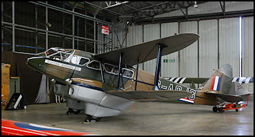 Preserved DH89 Dragon
Rapide G-AGJG
in wartime camouflage
Preserved DH89 Dragon
Rapide G-AGJG
in wartime camouflage
|
Some ATC Log Book
entries from September to December 1939 (click for larger)
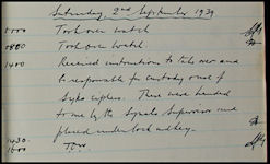 2nd September 1939
|
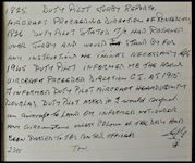 20th November 1939
|
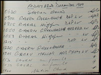 22 December 1939
|
RAF Jurby
RAF Jurby was conceived
under the 1930 expansion plan to provide training facilities to allow the
RAF to counteract the rapidly expanding Luftwaffe. It was designed
as an Armament Training Station to train gunners and bomb aimers, with
handy local bombing ranges being established just off Jurby Head and The
Ayres and also in Ramsey Bay. Construction started in late 1938 and
the grass airfield was ready for use by September 1939. More information
on RAF Jurby will be found in the 'ATC 1940s' section of this website.
 1940 'War Edition'
map of the Jurby area.
1940 'War Edition'
map of the Jurby area.
|
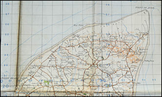
 1942 Aeronautical
Map of the Isle of Man
1942 Aeronautical
Map of the Isle of Man
|
ATC
in the 1940s
|